3D Atlas(EU): Difference between revisions
No edit summary |
|||
| (8 intermediate revisions by the same user not shown) | |||
| Line 1: | Line 1: | ||
[[Image: | [[Image:3D_Atlas_EU_Front.jpg|thumb|right|]] | ||
= Overview = | = Overview = | ||
| Line 17: | Line 17: | ||
== Summary == | == Summary == | ||
3D Atlas is an educational title which boasts 3D graphics on twelve different types of spinning globes, time lapse video sequences animations showing changes to the planer such as the destruction of the ozone layer and more. The title has been in production for some time, the credits show this release was also called 3D Atlas 98 and that before that there was a 3D Atlas 97, 3D Atlas (v1.1) and 3D Atlas(v1.0). The atlas has built in links to America On Line which held downloadable content. | |||
This version, and probably the earlier versions too, includes what is described as 'a challenging quiz' called 'Around The World' which can be played by one to three players. In their turn each player faces a round of five questions. Each question is timed and is worth a certain amount of points or air-miles, but that value decreases over time. When a round has been completed the game shows a humorous video of some form of transport, usually early aircraft. When all players have completed their round the game shoes a representation of the earth and how far the players have travelled with their accumulated air miles. | |||
Questions are obviously based on geography and countries of the world. Identifying a natoins flag is a common kind of question as is recognising a country from a picture of its scenery or a local market, knowledge of capital cities and major exports helps too. | |||
The quiz ends when a player has made a complete circuit of the earth. The scoreboard does not show high scores because a trip around the earth is always the same distance, instead it shows the percentage of questions answered correctly. | |||
3D Atlas for 3DO is an extremely data and art intensive educational product for the 3DO platform. It included 3d interactive globes generated from actual LANSAT data, interactive exhibits, video documentaries, 3d fly-throughs, a game, and literally thousands of statistics. | 3D Atlas for 3DO is an extremely data and art intensive educational product for the 3DO platform. It included 3d interactive globes generated from actual LANSAT data, interactive exhibits, video documentaries, 3d fly-throughs, a game, and literally thousands of statistics. | ||
Multidimensional Imagery and Navigation | Functions: | ||
'''Multidimensional Imagery and Navigation''' | |||
*3D spinning globes | |||
*Nine zoom levels of detail | |||
*Thousands of satellite images | |||
*3D flights | |||
'''Integrated Geographical Approach''' | |||
*Environmental globe | |||
*Physical globe | |||
*Political globe | |||
'''Interactive Multimedia Exhibits''' | |||
*Satellite photos of major cities | |||
*Dozens of video documentaries | |||
*Time lapse photography | |||
*Thousands of statistics | |||
'''Examine our world in 3 different visual contexts''' | |||
*environmental | |||
*physical | |||
*political | |||
== Other Versions == | |||
3D Atlas was released on other platforms such as the PC and Mac, revisions were completed upto 1997 on those platforms. | |||
== Media == | == Media == | ||
<gallery> | <gallery> | ||
3D_Atlas_EU_Back.jpg|Back of the box | |||
3D_Atlas_EU_Contents.jpg|Contents of the box | |||
3D_Atlas_1.png|Screenshot | |||
3D_Atlas_2.png|Screenshot | |||
3D_Atlas_3.jpg|Screenshot | |||
3D_Atlas_4.jpg|Screenshot | |||
3D_Atlas_5.jpg|Screenshot | |||
</gallery> | </gallery> | ||
[[Category:3DO Games]] | [[Category:3DO Games]] | ||
Latest revision as of 12:25, 6 June 2021

Overview
- Full Name: 3D Atlas
- Code:
- Type: Non-game, Edutainment
- Developer: The MultiMedia Corporation
- Publisher: Electronic Arts
- Language: English
- Release Date: 1994
- Region: EU
- Barcode: 5 015839 053221
- Local Title:
- Rarity: 1
- Notes:
Summary
3D Atlas is an educational title which boasts 3D graphics on twelve different types of spinning globes, time lapse video sequences animations showing changes to the planer such as the destruction of the ozone layer and more. The title has been in production for some time, the credits show this release was also called 3D Atlas 98 and that before that there was a 3D Atlas 97, 3D Atlas (v1.1) and 3D Atlas(v1.0). The atlas has built in links to America On Line which held downloadable content.
This version, and probably the earlier versions too, includes what is described as 'a challenging quiz' called 'Around The World' which can be played by one to three players. In their turn each player faces a round of five questions. Each question is timed and is worth a certain amount of points or air-miles, but that value decreases over time. When a round has been completed the game shows a humorous video of some form of transport, usually early aircraft. When all players have completed their round the game shoes a representation of the earth and how far the players have travelled with their accumulated air miles.
Questions are obviously based on geography and countries of the world. Identifying a natoins flag is a common kind of question as is recognising a country from a picture of its scenery or a local market, knowledge of capital cities and major exports helps too.
The quiz ends when a player has made a complete circuit of the earth. The scoreboard does not show high scores because a trip around the earth is always the same distance, instead it shows the percentage of questions answered correctly.
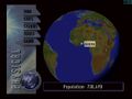
3D Atlas for 3DO is an extremely data and art intensive educational product for the 3DO platform. It included 3d interactive globes generated from actual LANSAT data, interactive exhibits, video documentaries, 3d fly-throughs, a game, and literally thousands of statistics.
Functions:
Multidimensional Imagery and Navigation
- 3D spinning globes
- Nine zoom levels of detail
- Thousands of satellite images
- 3D flights
Integrated Geographical Approach
- Environmental globe
- Physical globe
- Political globe
Interactive Multimedia Exhibits
- Satellite photos of major cities
- Dozens of video documentaries
- Time lapse photography
- Thousands of statistics
Examine our world in 3 different visual contexts
- environmental
- physical
- political
Other Versions
3D Atlas was released on other platforms such as the PC and Mac, revisions were completed upto 1997 on those platforms.
Media
-

Back of the box
-

Contents of the box
-
Screenshot
-

Screenshot
-
Screenshot
-
Screenshot
-

Screenshot


