3D Atlas(EU): Difference between revisions
No edit summary |
|||
| Line 1: | Line 1: | ||
[[Image: | [[Image:3D_Atlas_EU_Front.jpg|thumb|right|]] | ||
= Overview = | = Overview = | ||
| Line 42: | Line 42: | ||
<gallery> | <gallery> | ||
3D_Atlas_EU_Back.jpg|Back of the box | |||
3D_Atlas_EU_Contents.jpg|Contents of the box | |||
3D_Atlas_1.png|Screenshot | |||
3D_Atlas_2.png|Screenshot | |||
3D_Atlas_3.jpg|Screenshot | |||
3D_Atlas_4.jpg|Screenshot | |||
3D_Atlas_5.jpg|Screenshot | |||
</gallery> | </gallery> | ||
[[Category:3DO Games]] | [[Category:3DO Games]] | ||
Revision as of 11:02, 6 June 2021

Overview
- Full Name: 3D Atlas
- Code:
- Type: Non-game, Edutainment
- Developer: The MultiMedia Corporation
- Publisher: Electronic Arts
- Language: English
- Release Date: 1994
- Region: EU
- Barcode: 5 015839 053221
- Local Title:
- Rarity: 1
- Notes:
Summary
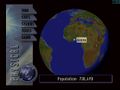
3D Atlas for 3DO is an extremely data and art intensive educational product for the 3DO platform. It included 3d interactive globes generated from actual LANSAT data, interactive exhibits, video documentaries, 3d fly-throughs, a game, and literally thousands of statistics.
Multidimensional Imagery and Navigation - 3D spinning globes - Nine zoom levels of detail - Thousands of satellite images - 3D flights
Integrated Geographical Approach - Environmental globe - Physical globe - Political globe
Interactive Multimedia Exhibits - Satellite photos of major cities - Dozens of video documentaries - Time lapse photography - Thousands of statistics
Examine our world in 3 different visual contexts - environmental, physical and political.
Media
-

Back of the box
-

Contents of the box
-
Screenshot
-

Screenshot
-

Screenshot
-
Screenshot
-

Screenshot


